
Make a donation
Bighton topographic map
Click on the map to display elevation.
Make a donation
About this map
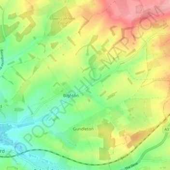
Name: Bighton topographic map, elevation, terrain.
Location: Bighton, Winchester, Hampshire, England, United Kingdom (51.09092 -1.14892 51.12544 -1.07209)
Average elevation: 121 m
Minimum elevation: 65 m
Maximum elevation: 197 m
Make a donation
Other topographic maps
Click on a map to view its topography, its elevation and its terrain.
Make a donation
Farley Chamberlayne
United Kingdom > England > Hampshire > Winchester > Hursley
Average elevation: 106 m
Make a donation
Dodsley Wood
United Kingdom > England > Hampshire > Winchester > East Stratton
Average elevation: 99 m
Store House Gully
United Kingdom > England > Hampshire > Winchester > Fisher's Pond
Average elevation: 45 m
Make a donation
Beacon Hill Nature Reserve
United Kingdom > England > Hampshire > Winchester > Exton
Average elevation: 128 m
Make a donation
Make a donation
Headbourne Worthy
United Kingdom > England > Hampshire > Winchester > Kings Worthy
Average elevation: 66 m
Make a donation
Old Winchester Hill Iron Age Fort
United Kingdom > England > Hampshire > Winchester
Average elevation: 123 m
Make a donation
Brambridge
United Kingdom > England > Hampshire > Winchester > Colden Common > Brambridge
Average elevation: 37 m
Make a donation
Norton Lake
United Kingdom > England > Hampshire > Winchester > Sutton Scotney > Norton
Average elevation: 72 m