
尼玛县 topographic map
Interactive map
Click on the map to display elevation.
About this map
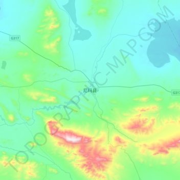
Name: 尼玛县 topographic map, elevation, terrain.
Location: 尼玛县, 尼玛镇, 尼玛县, 那曲市, 西藏自治区, 中国 (31.62726 87.07438 31.94726 87.39438)
Average elevation: 4,645 m
Minimum elevation: 4,465 m
Maximum elevation: 5,447 m
Other topographic maps
Click on a map to view its topography, its elevation and its terrain.