
Thank you for supporting this site ❤️
Make a donation
Make a donation
Bilstein topographic map
Click on the map to display elevation.
Thank you for supporting this site ❤️
Make a donation
Make a donation
Bilstein
Der Ort ist auf der Topographischen Aufnahme der Rheinlande von 1824 und auf der Preußischen Uraufnahme von 1840 als Bilstein verzeichnet. Ab der Preußischen Neuaufnahme von 1892 ist er auf Messtischblättern regelmäßig als Bilstein verzeichnet.
Thank you for supporting this site ❤️
Make a donation
Make a donation
About this map
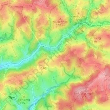
Name: Bilstein topographic map, elevation, terrain.
Average elevation: 246 m
Minimum elevation: 174 m
Maximum elevation: 312 m
Thank you for supporting this site ❤️
Make a donation
Make a donation
Other topographic maps
Click on a map to view its topography, its elevation and its terrain.
51515
Deutschland > Nordrhein-Westfalen > Rheinisch-Bergischer Kreis > Kürten > Waldmühle > Kettenberg
Average elevation: 218 m