
Thank you for supporting this site ❤️
Make a donation
Make a donation
Delan topographic map
Click on the map to display elevation.
Thank you for supporting this site ❤️
Make a donation
Make a donation
About this map
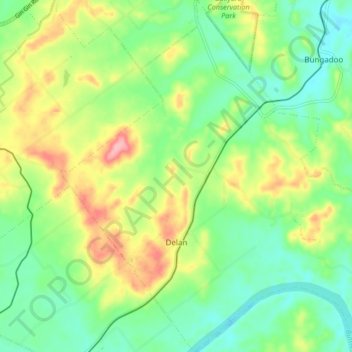
Name: Delan topographic map, elevation, terrain.
Location: Delan, Bundaberg Region, Queensland, Australia (-25.05094 152.01114 -24.97519 152.09139)
Average elevation: 58 m
Minimum elevation: 13 m
Maximum elevation: 135 m
Thank you for supporting this site ❤️
Make a donation
Make a donation
Other topographic maps
Click on a map to view its topography, its elevation and its terrain.
Isis River
Australia > Queensland > Bundaberg Region > South Isis > Isis River
Average elevation: 43 m
Thank you for supporting this site ❤️
Make a donation
Make a donation
Thank you for supporting this site ❤️
Make a donation
Make a donation