
Thank you for supporting this site ❤️
Make a donation
Make a donation
Arquennes topographic map
Click on the map to display elevation.
Thank you for supporting this site ❤️
Make a donation
Make a donation
About this map
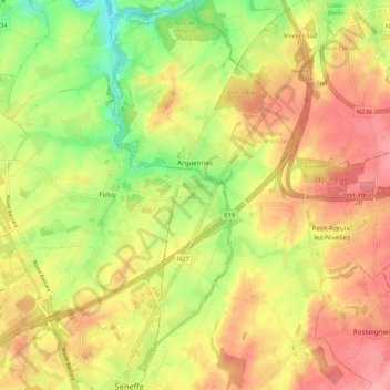
Name: Arquennes topographic map, elevation, terrain.
Location: Arquennes, Seneffe, Soignies, Hainaut, Wallonie, 7181, Belgique (50.52868 4.25112 50.59605 4.32067)
Average elevation: 119 m
Minimum elevation: 64 m
Maximum elevation: 162 m
Thank you for supporting this site ❤️
Make a donation
Make a donation
Other topographic maps
Click on a map to view its topography, its elevation and its terrain.