
Thank you for supporting this site ❤️
Make a donation
Make a donation
Cotia topographic map
Click on the map to display elevation.
Thank you for supporting this site ❤️
Make a donation
Make a donation
Cotia
Cotia is a municipality in the state of São Paulo in Brazil. It is part of the Metropolitan Region of São Paulo. The population is 253,608 (2020 est.) in an area of 323.99 km2. The city is at an elevation of 853 m. Cotia is linked with the Rodovia Raposo Tavares highway.
Thank you for supporting this site ❤️
Make a donation
Make a donation
About this map
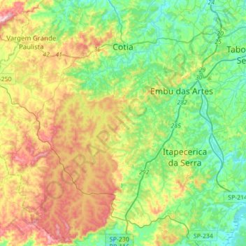
Name: Cotia topographic map, elevation, terrain.
Average elevation: 859 m
Minimum elevation: 731 m
Maximum elevation: 1,100 m
Thank you for supporting this site ❤️
Make a donation
Make a donation
Other topographic maps
Click on a map to view its topography, its elevation and its terrain.
Jardim Copacabana
Brazil > São Paulo > Região Metropolitana de São Paulo > São Paulo
Average elevation: 792 m