
Mandelshagen topographic map
Interactive map
Click on the map to display elevation.
About this map
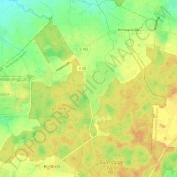
Name: Mandelshagen topographic map, elevation, terrain.
Average elevation: 48 m
Minimum elevation: 31 m
Maximum elevation: 59 m
Other topographic maps
Click on a map to view its topography, its elevation and its terrain.
Cordshagen
Deutschland > Mecklenburg-Vorpommern > Landkreis Rostock > Blankenhagen > Cordshagen
Cordshagen, Mandelshagen, Blankenhagen, Rostocker Heide, Landkreis Rostock, Mecklenburg-Vorpommern, Deutschland
Average elevation: 46 m