
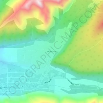
Shangri La topographic map
Interactive map
Click on the map to display elevation.
About this map
Name: Shangri La topographic map, elevation, terrain.
Average elevation: 1,409 m
Minimum elevation: 1,161 m
Maximum elevation: 1,938 m
Other topographic maps
Click on a map to view its topography, its elevation and its terrain.
Las Trancas
Chile > Región de Ñuble > Provincia de Diguillín > Pinto
Las Trancas, Pinto, Provincia de Diguillín, Región de Ñuble, Chile
Average elevation: 1,415 m
Las Termas de Chillán
Chile > Región de Ñuble > Provincia de Diguillín > Pinto
Las Termas de Chillán, Pinto, Provincia de Diguillín, Región de Ñuble, Chile
Average elevation: 1,790 m