
Brentwood Estates topographic map
Interactive map
Click on the map to display elevation.
About this map
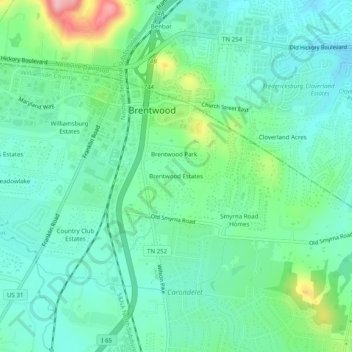
Name: Brentwood Estates topographic map, elevation, terrain.
Average elevation: 221 m
Minimum elevation: 181 m
Maximum elevation: 339 m
Other topographic maps
Click on a map to view its topography, its elevation and its terrain.
Forest of Brentwood
United States > Tennessee > Williamson County > Brentwood
Forest of Brentwood, Brentwood, Williamson County, Tennessee, 37609, United States
Average elevation: 234 m
Mooreland Estates
United States > Tennessee > Williamson County > Brentwood > Mooreland Estates
Mooreland Estates, Brentwood, Williamson County, Tennessee, 37607, United States
Average elevation: 244 m