
St. Joe topographic map
Interactive map
Click on the map to display elevation.
About this map
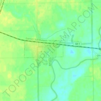
Name: St. Joe topographic map, elevation, terrain.
Location: St. Joe, DeKalb County, Indiana, United States (41.31019 -84.91117 41.31833 -84.89139)
Average elevation: 250 m
Minimum elevation: 240 m
Maximum elevation: 257 m
Other topographic maps
Click on a map to view its topography, its elevation and its terrain.
Spencerville
United States > Indiana > DeKalb County
Spencerville, DeKalb County, Indiana, 46788, United States
Average elevation: 249 m
Corunna
United States > Indiana > DeKalb County
Corunna, DeKalb County, Indiana, United States
Average elevation: 295 m
Altona
United States > Indiana > DeKalb County
Altona, DeKalb County, Indiana, United States
Average elevation: 271 m
Ashley
United States > Indiana > DeKalb County
Ashley, DeKalb County, Indiana, 46705, United States
Average elevation: 303 m
Butler
United States > Indiana > DeKalb County
Butler, DeKalb County, Indiana, United States
Average elevation: 265 m
Waterloo
United States > Indiana > DeKalb County
Waterloo, DeKalb County, Indiana, United States
Average elevation: 276 m
Stafford Center
United States > Indiana > DeKalb County
Stafford Center, DeKalb County, Indiana, 46721, United States
Average elevation: 258 m
Garrett
United States > Indiana > DeKalb County
Garrett, DeKalb County, Indiana, 46738, United States
Average elevation: 270 m