
Thank you for supporting this site ❤️
Make a donation
Make a donation
Rod am Berg topographic map
Click on the map to display elevation.
Thank you for supporting this site ❤️
Make a donation
Make a donation
About this map
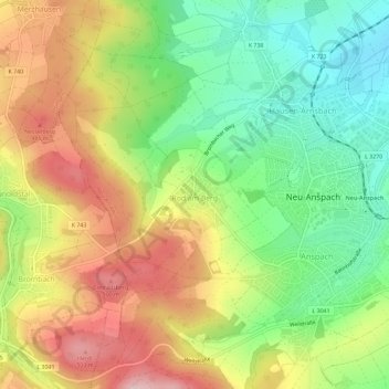
Name: Rod am Berg topographic map, elevation, terrain.
Location: Rod am Berg, Neu-Anspach, Hochtaunuskreis, Hessen, Deutschland (50.28198 8.46934 50.31873 8.50396)
Average elevation: 392 m
Minimum elevation: 285 m
Maximum elevation: 519 m
Thank you for supporting this site ❤️
Make a donation
Make a donation
Other topographic maps
Click on a map to view its topography, its elevation and its terrain.
Rod am Berg
Deutschland > Hessen > Hochtaunuskreis > Neu-Anspach > Rod am Berg
Average elevation: 393 m