
Thank you for supporting this site ❤️
Make a donation
Make a donation
Seidões topographic map
Click on the map to display elevation.
Thank you for supporting this site ❤️
Make a donation
Make a donation
About this map
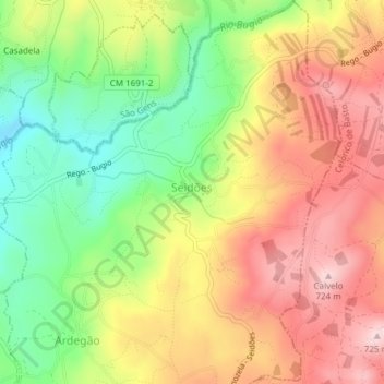
Name: Seidões topographic map, elevation, terrain.
Average elevation: 597 m
Minimum elevation: 458 m
Maximum elevation: 713 m
Thank you for supporting this site ❤️
Make a donation
Make a donation
Other topographic maps
Click on a map to view its topography, its elevation and its terrain.
Thank you for supporting this site ❤️
Make a donation
Make a donation
Fafe
Fafe situa-se num vale entre a Serra da Lameira, os Montes da Penha e outras montanhas. Numa vista aérea destacam-se três rios ladeados por arvoredo e que se espreguiçam pela periferia da cidade. São eles o Rio Ferro que tem a sua nascente em Ribeiros, o Rio do Bugio que inicia o seu percurso para os lados…
Average elevation: 386 m
Thank you for supporting this site ❤️
Make a donation
Make a donation
Thank you for supporting this site ❤️
Make a donation
Make a donation
Thank you for supporting this site ❤️
Make a donation
Make a donation