
Make a donation
Aholming topographic map
Click on the map to display elevation.
Make a donation
About this map
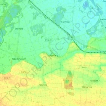
Name: Aholming topographic map, elevation, terrain.
Location: Aholming, Landkreis Deggendorf, Bayern, 94527, Deutschland (48.70445 12.84311 48.76883 12.93807)
Average elevation: 325 m
Minimum elevation: 312 m
Maximum elevation: 342 m
Make a donation
Other topographic maps
Click on a map to view its topography, its elevation and its terrain.
Make a donation
Rechter Plattlinger Mühlbach
Deutschland > Bayern > Landkreis Deggendorf > Plattling
Average elevation: 319 m
Make a donation
Make a donation
Ernading
Deutschland > Bayern > Landkreis Deggendorf > Grattersdorf > Grattersdorf
Average elevation: 463 m
Make a donation
Großwalding
Deutschland > Bayern > Landkreis Deggendorf > Deggendorf > Kleinfilling
Average elevation: 420 m
Make a donation
Make a donation
Make a donation
Klotzing
Deutschland > Bayern > Landkreis Deggendorf > Deggendorf > Großfilling
Average elevation: 463 m
Thannberg
Deutschland > Bayern > Landkreis Deggendorf > Deggendorf > Oberkandelbach
Average elevation: 395 m
Stauffendorf
Deutschland > Bayern > Landkreis Deggendorf > Deggendorf > Rettenbach
Average elevation: 319 m
Make a donation
Make a donation
Make a donation
Make a donation
Kleineichberg
Deutschland > Bayern > Landkreis Deggendorf > Deggendorf > Eichberg
Average elevation: 384 m
Make a donation
Make a donation
Ruselabsatz
Deutschland > Bayern > Landkreis Deggendorf > Schaufling > Ruselabsatz
Average elevation: 759 m
Make a donation
Kurzenisarhofen
Deutschland > Bayern > Landkreis Deggendorf > Langenisarhofen > Kurzenisarhofen
Average elevation: 320 m
Make a donation
Make a donation
Scheidham
Deutschland > Bayern > Landkreis Deggendorf > Deggendorf > Reinprechting
Average elevation: 415 m
Make a donation
Make a donation