
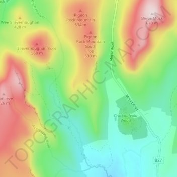
Mourne Mountains Middle topographic map
Interactive map
Click on the map to display elevation.
About this map
Name: Mourne Mountains Middle topographic map, elevation, terrain.
Average elevation: 348 m
Minimum elevation: 132 m
Maximum elevation: 670 m
Other topographic maps
Click on a map to view its topography, its elevation and its terrain.
Derry/Londonderry
United Kingdom > Northern Ireland > County Londonderry
Derry/Londonderry, County Borough of Londonderry, County Londonderry, Northern Ireland, BT48 6BU, United Kingdom
Average elevation: 88 m
County Tyrone
United Kingdom > Northern Ireland
County Tyrone, Northern Ireland, United Kingdom
Average elevation: 120 m
Killyberry Boyd
United Kingdom > Northern Ireland
Killyberry Boyd, Northern Ireland, United Kingdom
Average elevation: 35 m
Hilltown
United Kingdom > Northern Ireland > County Down
Hilltown, County Down, Northern Ireland, BT34 5UH, United Kingdom
Average elevation: 136 m
Newcastle Road
United Kingdom > Northern Ireland
Newcastle Road, Northern Ireland, United Kingdom
Average elevation: 8 m
Newtownards
United Kingdom > Northern Ireland > County Down
Newtownards, County Down, Northern Ireland, BT23 4FA, United Kingdom
Average elevation: 50 m
Whiterock
United Kingdom > Northern Ireland > County Down
Whiterock, County Down, Northern Ireland, BT23 6QH, United Kingdom
Average elevation: 11 m
Binian Lough
United Kingdom > Northern Ireland > County Down
Binian Lough, County Down, Northern Ireland, United Kingdom
Average elevation: 411 m
Clough
United Kingdom > Northern Ireland > County Down
Clough, County Down, Ulster, Northern Ireland, BT30 8RB, United Kingdom
Average elevation: 32 m
Belfast
United Kingdom > Northern Ireland > County Antrim
Belfast, County Antrim, Northern Ireland, United Kingdom
Average elevation: 92 m
Giant's Causeway
United Kingdom > Northern Ireland > County Antrim
Giant's Causeway, County Antrim, Ulster, Northern Ireland, United Kingdom
Average elevation: 26 m
Cave Hill
United Kingdom > Northern Ireland > County Antrim > Belfast
Cave Hill, Greencastle, Belfast, County Antrim, Northern Ireland, BT15 5GL, United Kingdom
Average elevation: 172 m
Whitecross
United Kingdom > Northern Ireland
Whitecross, Newry, Mourne and Down District Council, Northern Ireland, BT60 2UF, United Kingdom
Average elevation: 127 m
West Division
United Kingdom > Northern Ireland
West Division, Northern Ireland, United Kingdom
Average elevation: 128 m
Crossmaglen
United Kingdom > Northern Ireland
Crossmaglen, Newry, Mourne and Down District Council, Northern Ireland, United Kingdom
Average elevation: 123 m
Cappagh
United Kingdom > Northern Ireland
Cappagh, Northern Ireland, United Kingdom
Average elevation: 234 m
Drumragh (Caldwell)
United Kingdom > Northern Ireland > County Tyrone
Drumragh (Caldwell), County Tyrone, Ulster, Northern Ireland, United Kingdom
Average elevation: 87 m
Dungannon
United Kingdom > Northern Ireland > County Tyrone
Dungannon, County Tyrone, Northern Ireland, BT70 1BD, United Kingdom
Average elevation: 76 m
Carryduff
United Kingdom > Northern Ireland > County Down
Carryduff, County Down, Ulster, Northern Ireland, BT8 8DN, United Kingdom
Average elevation: 110 m
Portadown
United Kingdom > Northern Ireland > County Armagh
Portadown, County Armagh, Ulster, Northern Ireland, BT62 1BF, United Kingdom
Average elevation: 28 m
Loughgall
United Kingdom > Northern Ireland > County Armagh
Loughgall, County Armagh, Ulster, Northern Ireland, BT61 8HY, United Kingdom
Average elevation: 32 m
Belcoo
United Kingdom > Northern Ireland > County Fermanagh
Belcoo, County Fermanagh, Ulster, Northern Ireland, BT93 5FB, United Kingdom
Average elevation: 86 m
Ahoghill
United Kingdom > Northern Ireland > County Antrim
Ahoghill, County Antrim, Ulster, Northern Ireland, BT42 1JZ, United Kingdom
Average elevation: 84 m
Moher
United Kingdom > Northern Ireland > County Fermanagh
Moher, Lea, County Fermanagh, Ulster, Northern Ireland, BT92 4FJ, United Kingdom
Average elevation: 65 m
Aughnahoory
United Kingdom > Northern Ireland > County Down > Kilkeel
Aughnahoory, Kilkeel, County Down, Ulster, Northern Ireland, United Kingdom
Average elevation: 60 m
County Armagh
United Kingdom > Northern Ireland
County Armagh, Ulster, Northern Ireland, United Kingdom
Average elevation: 98 m
County Londonderry
United Kingdom > Northern Ireland
County Londonderry, Ulster, Northern Ireland, United Kingdom
Average elevation: 128 m
Tempo
United Kingdom > Northern Ireland > County Fermanagh
Tempo, County Fermanagh, Ulster, Northern Ireland, BT94 3LU, United Kingdom
Average elevation: 127 m
Ballyfatten
United Kingdom > Northern Ireland
Ballyfatten, Ulster, Northern Ireland, BT82 9PY, United Kingdom
Average elevation: 34 m
Coleraine
United Kingdom > Northern Ireland > County Londonderry
Coleraine, County Londonderry, Ulster, Northern Ireland, BT52 1EP, United Kingdom
Average elevation: 40 m
McLean's Hill
United Kingdom > Northern Ireland > County Down > Bryansford
McLean's Hill, Bryansford, County Down, Ulster, Northern Ireland, BT31 9HH, United Kingdom
Average elevation: 93 m
Carr
United Kingdom > Northern Ireland
Carr, Ulster, Northern Ireland, United Kingdom
Average elevation: 60 m
Horse Island
United Kingdom > Northern Ireland > County Fermanagh
Horse Island, County Fermanagh, Ulster, Northern Ireland, United Kingdom
Average elevation: 46 m
Armagh
United Kingdom > Northern Ireland > County Armagh > Armagh
Armagh, County Armagh, Ulster, Northern Ireland, United Kingdom
Average elevation: 100 m
Newry
United Kingdom > Northern Ireland > County Down > Newry
Newry, County Down, Northern Ireland, BT34 1DG, United Kingdom
Average elevation: 129 m
Limavady
United Kingdom > Northern Ireland > County Londonderry
Limavady, County Londonderry, Ulster, Northern Ireland, BT49 0EP, United Kingdom
Average elevation: 37 m
Upper Ballysillan
United Kingdom > Northern Ireland > County Antrim
Upper Ballysillan, County Antrim, Northern Ireland, United Kingdom
Average elevation: 254 m
Glynn
United Kingdom > Northern Ireland > County Antrim > Glynn
Glynn, County Antrim, Northern Ireland, BT40 3HF, United Kingdom
Average elevation: 63 m
Armagh
United Kingdom > Northern Ireland > Armagh
Armagh, County Armagh, Northern Ireland, BT61 7DJ, United Kingdom
Average elevation: 85 m
County Antrim
United Kingdom > Northern Ireland
County Antrim, Northern Ireland, United Kingdom
Average elevation: 70 m
Groomsport
United Kingdom > Northern Ireland > County Down > Groomsport
Groomsport, County Down, Northern Ireland, BT19 6JR, United Kingdom
Average elevation: 10 m
Newry
United Kingdom > Northern Ireland > County Down > Newry
Newry, County Down, Northern Ireland, United Kingdom
Average elevation: 73 m
Lough Aghery
United Kingdom > Northern Ireland
Lough Aghery, County Down, Northern Ireland, United Kingdom
Average elevation: 129 m
Larne
United Kingdom > Northern Ireland > County Antrim > Larne
Larne, County Antrim, Northern Ireland, BT40 1HU, United Kingdom
Average elevation: 54 m
Banbridge
United Kingdom > Northern Ireland > County Down
Banbridge, County Down, Ulster, Northern Ireland, BT32 3AD, United Kingdom
Average elevation: 90 m
Dromore
United Kingdom > Northern Ireland > County Down
Dromore, County Down, Northern Ireland, BT25 1BL, United Kingdom
Average elevation: 106 m
Heron Island
United Kingdom > Northern Ireland > County Fermanagh
Heron Island, County Fermanagh, Ulster, Northern Ireland, United Kingdom
Average elevation: 47 m
Belfast
United Kingdom > Northern Ireland > County Antrim
Belfast, County Antrim, Ulster, Northern Ireland, BT1 5GS, United Kingdom
Average elevation: 87 m
Annaclone
United Kingdom > Northern Ireland > Katesbridge
Annaclone, Katesbridge, County Down, Northern Ireland, United Kingdom
Average elevation: 107 m
White Island
United Kingdom > Northern Ireland
White Island, County Fermanagh, Northern Ireland, United Kingdom
Average elevation: 48 m