
Thank you for supporting this site ❤️
Make a donation
Make a donation
Wrocław topographic map
Click on the map to display elevation.
Thank you for supporting this site ❤️
Make a donation
Make a donation
Wrocław
Wrocław is located in the three mesoregions of the Silesian Lowlands (Wrocław Plain, Wrocław Valley, Oleśnica Plain) at an elevation of around 156 – 170 metres (Gajowe Hill and Maślickie Hill) above sea level.[104] The city lies on the Oder River and its four tributaries, which supply it within the city limits – Bystrzyca, Oława, Ślęza and Widawa.[105] In addition, the Dobra River and many streams flow through the city. The city has a sewage treatment plant on the Janówek estate.[106]
Thank you for supporting this site ❤️
Make a donation
Make a donation
About this map
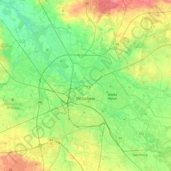
Name: Wrocław topographic map, elevation, terrain.
Location: Wrocław, Lower Silesian Voivodeship, Poland (51.04267 16.80734 51.21006 17.17622)
Average elevation: 124 m
Minimum elevation: 99 m
Maximum elevation: 173 m
Thank you for supporting this site ❤️
Make a donation
Make a donation