
Thank you for supporting this site ❤️
Make a donation
Make a donation
Garín topographic map
Click on the map to display elevation.
Thank you for supporting this site ❤️
Make a donation
Make a donation
About this map
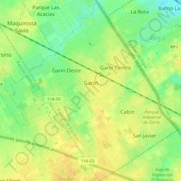
Name: Garín topographic map, elevation, terrain.
Location: Garín, Partido de Escobar, Buenos Aires, Argentina (-34.45644 -58.76538 -34.39689 -58.70551)
Average elevation: 17 m
Minimum elevation: 2 m
Maximum elevation: 29 m
Thank you for supporting this site ❤️
Make a donation
Make a donation
Other topographic maps
Click on a map to view its topography, its elevation and its terrain.
Thank you for supporting this site ❤️
Make a donation
Make a donation
Thank you for supporting this site ❤️
Make a donation
Make a donation
General San Martín
Argentina > Buenos Aires > General San Martín > General San Martín
Average elevation: 25 m
Thank you for supporting this site ❤️
Make a donation
Make a donation