
Make a donation
Tabanan topographic map
Click on the map to display elevation.
Make a donation
Tabanan
Jatiluwih village in Penebel District, north of Tabanan, has paddy fields following the contours of terraced land against the background of spellbinding Mount Batukaru and Mount Agung use traditional Balinese irrigation known as subak, Bali's community-based water control management system. Lies at an altitude of 700 meters, the cool atmosphere of more original beautiful Jatiluwih is better than the most well-known Tegallalang which has plenty of cafes and souvenir shops. Two routes to Jatiluwih are Denpasar>Kediri>Tabanan>Penebel>Jatiluwih or Denpasar>Mengwi>Baturiti>Jatiluwih. Jatiluwih is one of the five rice terraces that describe the "Subak" water management system which has gain acknowledgment from UNESCO as part of the world's cultural heritage.
Make a donation
About this map
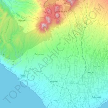
Name: Tabanan topographic map, elevation, terrain.
Location: Tabanan, Bali, Indonesia (-8.63601 114.91527 -8.24317 115.21733)
Average elevation: 450 m
Minimum elevation: 0 m
Maximum elevation: 2,235 m
Make a donation
Other topographic maps
Click on a map to view its topography, its elevation and its terrain.
Make a donation
Make a donation