
Río Achibueno topographic map
Interactive map
Click on the map to display elevation.
About this map
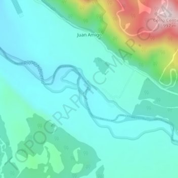
Name: Río Achibueno topographic map, elevation, terrain.
Average elevation: 586 m
Minimum elevation: 480 m
Maximum elevation: 993 m
Other topographic maps
Click on a map to view its topography, its elevation and its terrain.
Chupallar Bajo
Chile > Región del Maule > Linares > Chupallar Bajo
Chupallar Bajo, Linares, Provincia de Linares, Región del Maule, Chile
Average elevation: 715 m