
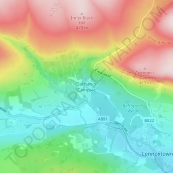
Clachan of Campsie topographic map
Interactive map
Click on the map to display elevation.
About this map
Name: Clachan of Campsie topographic map, elevation, terrain.
Average elevation: 226 m
Minimum elevation: 59 m
Maximum elevation: 485 m
Other topographic maps
Click on a map to view its topography, its elevation and its terrain.
Twechar
United Kingdom > Scotland > East Dunbartonshire
Twechar, East Dunbartonshire, Scotland, G65 9SA, United Kingdom
Average elevation: 64 m
Bearsden
United Kingdom > Scotland > East Dunbartonshire
Bearsden, East Dunbartonshire, Scotland, G61 3RU, United Kingdom
Average elevation: 72 m
Kirkintilloch
United Kingdom > Scotland > East Dunbartonshire
Kirkintilloch, East Dunbartonshire, Scotland, G66 1HF, United Kingdom
Average elevation: 68 m
Milngavie
United Kingdom > Scotland > East Dunbartonshire
Milngavie, East Dunbartonshire, Scotland, G62 6BH, United Kingdom
Average elevation: 99 m
Craigmaddie Reservoir
United Kingdom > Scotland > East Dunbartonshire > Milngavie
Craigmaddie Reservoir, Milngavie, East Dunbartonshire, Scotland, United Kingdom
Average elevation: 97 m
Fauldhead
United Kingdom > Scotland > East Dunbartonshire > Lenzie
Fauldhead, Lenzie, East Dunbartonshire, Scotland, United Kingdom
Average elevation: 62 m
Lenzie
United Kingdom > Scotland > East Dunbartonshire
Lenzie, East Dunbartonshire, Scotland, G66 5ER, United Kingdom
Average elevation: 68 m
Milton of Campsie
United Kingdom > Scotland > East Dunbartonshire
Milton of Campsie, East Dunbartonshire, Scotland, G66 8BU, United Kingdom
Average elevation: 80 m
Lennoxtown
United Kingdom > Scotland > East Dunbartonshire
Lennoxtown, East Dunbartonshire, Scotland, G66 7DB, United Kingdom
Average elevation: 199 m
Bishopbriggs
United Kingdom > Scotland > East Dunbartonshire
Bishopbriggs, East Dunbartonshire, Scotland, G64 2RA, United Kingdom
Average elevation: 60 m
Bardowie
United Kingdom > Scotland > East Dunbartonshire
Bardowie, East Dunbartonshire, Scotland, G62 6ES, United Kingdom
Average elevation: 58 m