
Plattsville topographic map
Interactive map
Click on the map to display elevation.
About this map
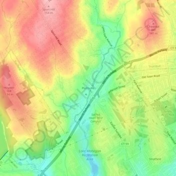
Name: Plattsville topographic map, elevation, terrain.
Average elevation: 84 m
Minimum elevation: 13 m
Maximum elevation: 150 m
Other topographic maps
Click on a map to view its topography, its elevation and its terrain.
Aspetuck
United States > Connecticut > Greater Bridgeport Planning Region > Easton
Aspetuck, Easton, Greater Bridgeport Planning Region, Connecticut, 06883, United States
Average elevation: 83 m