
顿河畔罗斯托夫 topographic map
Interactive map
Click on the map to display elevation.
About this map
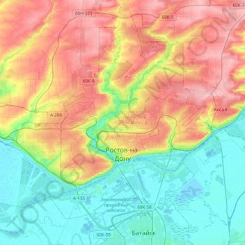
Name: 顿河畔罗斯托夫 topographic map, elevation, terrain.
Location: 顿河畔罗斯托夫, 罗斯托夫州, 南部联邦管区, 俄罗斯 (47.15338 39.47099 47.35557 39.85139)
Average elevation: 51 m
Minimum elevation: -8 m
Maximum elevation: 123 m