
Thank you for supporting this site ❤️
Make a donation
Make a donation
La Garde topographic map
Click on the map to display elevation.
Thank you for supporting this site ❤️
Make a donation
Make a donation
About this map
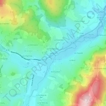
Name: La Garde topographic map, elevation, terrain.
Average elevation: 349 m
Minimum elevation: 260 m
Maximum elevation: 597 m
Thank you for supporting this site ❤️
Make a donation
Make a donation
Other topographic maps
Click on a map to view its topography, its elevation and its terrain.
Clermain
France > Bourgogne-Franche-Comté > Saône-et-Loire > Navour-sur-Grosne
Average elevation: 347 m
Brandon
France > Bourgogne-Franche-Comté > Saône-et-Loire > Navour-sur-Grosne
Average elevation: 370 m