
Make a donation
Harper topographic map
Click on the map to display elevation.
Make a donation
About this map
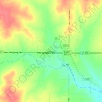
Name: Harper topographic map, elevation, terrain.
Location: Harper, Gillespie County, Texas, 78631, United States (30.28073 -99.27084 30.32073 -99.23084)
Average elevation: 634 m
Minimum elevation: 599 m
Maximum elevation: 668 m
Make a donation
Other topographic maps
Click on a map to view its topography, its elevation and its terrain.
Fredericksburg
United States > Texas > Gillespie County
Enchanted Rock is a geographical landmark 27 km (17 mi) north of Fredericksburg in Llano County. The rock is a huge, pink granite exfoliation dome that rises 425 ft (130 m) above the surrounding land, has a summit elevation of 1,825 ft (556 m) above sea level, and covers 640 acres (260 ha). Enchanted Rock…
Average elevation: 526 m
Make a donation