
Thank you for supporting this site ❤️
Make a donation
Make a donation
Karijini topographic map
Click on the map to display elevation.
Thank you for supporting this site ❤️
Make a donation
Make a donation
About this map
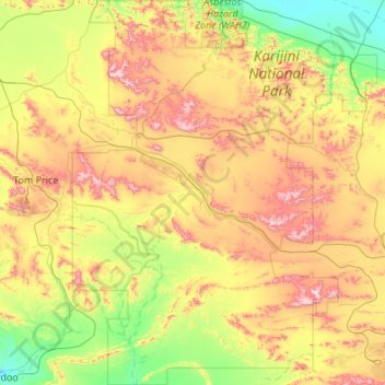
Name: Karijini topographic map, elevation, terrain.
Location: Karijini, Shire Of Ashburton, Western Australia, Australia (-23.22069 117.90022 -22.22207 118.75847)
Average elevation: 688 m
Minimum elevation: 403 m
Maximum elevation: 1,229 m
Thank you for supporting this site ❤️
Make a donation
Make a donation
Other topographic maps
Click on a map to view its topography, its elevation and its terrain.
Perth
Australia > Western Australia > City of Perth
Perth, the capital of Western Australia, is situated on the Swan Coastal Plain, a flat expanse of sandy soil nestled between the Indian Ocean to the west and the Darling Scarp to the east. The Darling Scarp, also known as the Darling Range, is a low escarpment that extends north–south, marking a distinct…
Average elevation: 26 m