
Memesagamesing Lake topographic map
Interactive map
Click on the map to display elevation.
About this map
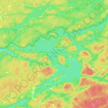
Name: Memesagamesing Lake topographic map, elevation, terrain.
Average elevation: 230 m
Minimum elevation: 203 m
Maximum elevation: 266 m
Other topographic maps
Click on a map to view its topography, its elevation and its terrain.
Rivière des Français
Canada > Ontario > Unorganized Centre Parry Sound
Rivière des Français, Unorganized Centre Parry Sound, Parry Sound District, Central Ontario, Ontario, P0M 1A0, Canada
Average elevation: 193 m