
Tuen Mun District topographic map
Interactive map
Click on the map to display elevation.
About this map
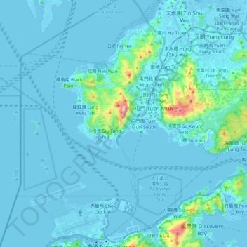
Name: Tuen Mun District topographic map, elevation, terrain.
Location: Tuen Mun District, New Territories, Hong Kong, China (22.32435 113.86587 22.43340 114.06620)
Average elevation: 37 m
Minimum elevation: -15 m
Maximum elevation: 546 m
Other topographic maps
Click on a map to view its topography, its elevation and its terrain.
Hong Kong
Hong Kong has a humid subtropical climate (Köppen Cwa), characteristic of southern China. Summer is hot and humid, with occasional showers and thunderstorms and warm air from the southwest. Typhoons occur most often then, sometimes resulting in floods or landslides. Winters are mild and usually sunny at the…
Average elevation: 62 m