
Thank you for supporting this site ❤️
Make a donation
Make a donation
Lac Mial topographic map
Click on the map to display elevation.
Thank you for supporting this site ❤️
Make a donation
Make a donation
About this map
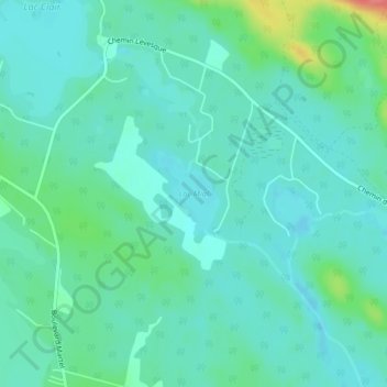
Name: Lac Mial topographic map, elevation, terrain.
Average elevation: 193 m
Minimum elevation: 178 m
Maximum elevation: 250 m
Thank you for supporting this site ❤️
Make a donation
Make a donation
Other topographic maps
Click on a map to view its topography, its elevation and its terrain.
Mont Victor-Tremblay
Canada > Québec > Le Fjord-du-Saguenay > Saint-David-de-Falardeau
Average elevation: 626 m
Lac Brochet
Canada > Québec > Le Fjord-du-Saguenay > Saint-David-de-Falardeau
Average elevation: 214 m
Lac Sébastien
Canada > Québec > Le Fjord-du-Saguenay > Saint-David-de-Falardeau
Average elevation: 185 m
Thank you for supporting this site ❤️
Make a donation
Make a donation