
Fountain Green topographic map
Interactive map
Click on the map to display elevation.
About this map
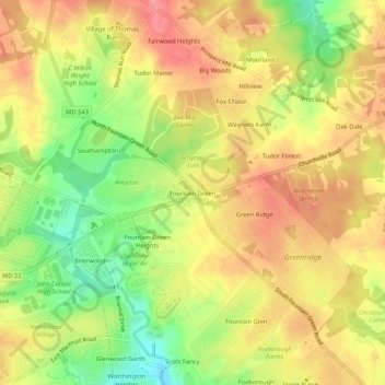
Name: Fountain Green topographic map, elevation, terrain.
Average elevation: 106 m
Minimum elevation: 60 m
Maximum elevation: 138 m
Other topographic maps
Click on a map to view its topography, its elevation and its terrain.
Mount Soma Reservoir
United States > Maryland > Harford County > Bel Air
Mount Soma Reservoir, Bel Air Acres, Bel Air, Harford County, Maryland, United States
Average elevation: 91 m
North Bel Air
United States > Maryland > Harford County > Bel Air
North Bel Air, Bel Air, Harford County, Maryland, 21014, United States
Average elevation: 109 m