
Fritch topographic map
Interactive map
Click on the map to display elevation.
About this map
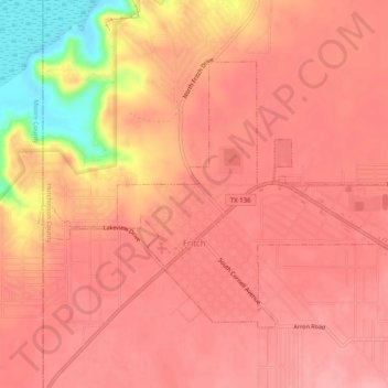
Name: Fritch topographic map, elevation, terrain.
Location: Fritch, Hutchinson County, Texas, United States (35.63090 -101.62344 35.65886 -101.57331)
Average elevation: 965 m
Minimum elevation: 883 m
Maximum elevation: 988 m
Fritch is primarily a bedroom community, with the majority of citizens commuting to nearby Borger and Amarillo for work. Major employers in the area include Pantex, ConocoPhillips, and Agrium, all located within a short distance of Fritch. Due to its nature as a commuting town, Fritch differs from most small towns in the region, which rely more on agriculture as their economic base. Though several large ranches are adjacent to the town, little to no farming occurs due to the uneven topography, and the town has few agriculture-related services.
Other topographic maps
Click on a map to view its topography, its elevation and its terrain.
Phillips
United States > Texas > Hutchinson County
Phillips, Hutchinson County, Texas, 79007, United States
Average elevation: 905 m
Stinnett
United States > Texas > Hutchinson County
Stinnett, Hutchinson County, Texas, United States
Average elevation: 977 m
Lake Meredith
United States > Texas > Hutchinson County
Lake Meredith, Hutchinson County, Texas, United States
Average elevation: 906 m
Borger
United States > Texas > Hutchinson County
Borger, Hutchinson County, Texas, 79007, United States
Average elevation: 929 m