
Saint-Antoine topographic map
Interactive map
Click on the map to display elevation.
About this map
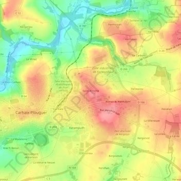
Name: Saint-Antoine topographic map, elevation, terrain.
Average elevation: 128 m
Minimum elevation: 77 m
Maximum elevation: 169 m
Other topographic maps
Click on a map to view its topography, its elevation and its terrain.
Le Petit-Carhaix
France > Bretagne > Finistère > Carhaix-Plouguer
Le Petit-Carhaix, Carhaix-Plouguer, Châteaulin, Finistère, Bretagne, France métropolitaine, 29270, France
Average elevation: 118 m
Kerampuilh
France > Bretagne > Finistère > Carhaix-Plouguer > Kerampuilh
Kerampuilh, Carhaix-Plouguer, Châteaulin, Finistère, Bretagne, France métropolitaine, 29270, France
Average elevation: 127 m