
Irondale topographic map
Interactive map
Click on the map to display elevation.
About this map
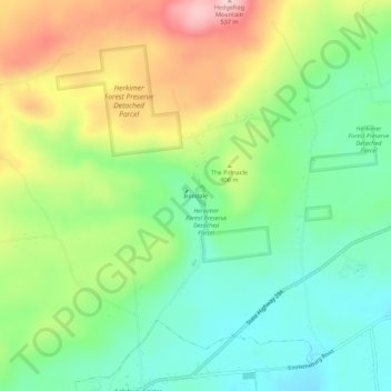
Name: Irondale topographic map, elevation, terrain.
Average elevation: 383 m
Minimum elevation: 292 m
Maximum elevation: 530 m
Other topographic maps
Click on a map to view its topography, its elevation and its terrain.
Paper Mill Corners
United States > New York > Herkimer County > Town of Salisbury
Paper Mill Corners, Town of Salisbury, Herkimer County, New York, United States
Average elevation: 407 m
Salisbury Center
United States > New York > Herkimer County > Town of Salisbury
Salisbury Center, Town of Salisbury, Herkimer County, New York, United States
Average elevation: 334 m
Curtis
United States > New York > Herkimer County > Town of Salisbury
Curtis, Town of Salisbury, Herkimer County, New York, United States
Average elevation: 429 m
Ives Hollow
United States > New York > Herkimer County > Town of Salisbury
Ives Hollow, Town of Salisbury, Herkimer County, New York, United States
Average elevation: 382 m