
Central Province topographic map
Interactive map
Click on the map to display elevation.
About this map
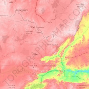
Name: Central Province topographic map, elevation, terrain.
Location: Central Province, Zambia (-15.75348 25.31369 -12.02942 31.43974)
Average elevation: 1,059 m
Minimum elevation: 314 m
Maximum elevation: 1,802 m
Other topographic maps
Click on a map to view its topography, its elevation and its terrain.
Solwezi
Zambia > North-Western Province
Solwezi is located on the Chingola–Solwezi–Mwinilunga Road (T5 Road of Zambia), approximately 177 kilometres (110 mi) north-west of Chingola[2] and approximately 275 kilometres (171 mi) south-east of Mwinilunga, in the extreme northwest of the country.[3] The geographical coordinates of the city…
Average elevation: 1,352 m