
Maritime Alps topographic map
Interactive map
Click on the map to display elevation.
Maritime Alps
Its topography is very mixed. As its name suggests, most of the department is a constituent part of the overall topographic Alps – including the Maritime Alps – but it also has the distinction of being a coastal district with its Mediterranean coast. The coastal area, urbanized and densely populated (shaded in red on the map), includes all the cities in an almost continuous conurbation from Cannes to Menton, while the larger but sparsely populated mountainous area (light green) is fully rural with the exception of the three large resorts of Valberg (created in 1936), Auron (created in 1937) and Isola 2000 (created in 1971).
About this map
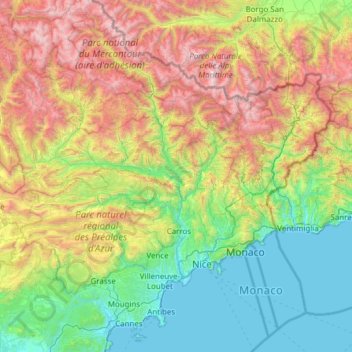
Name: Maritime Alps topographic map, elevation, terrain.
Average elevation: 971 m
Minimum elevation: 0 m
Maximum elevation: 3,275 m
Other topographic maps
Click on a map to view its topography, its elevation and its terrain.
Molanès
France > Provence-Alpes-Côte d'Azur > Alpes-de-Haute-Provence > Uvernet-Fours
Average elevation: 1,566 m
Ailefroide
France > Provence-Alpes-Côte d'Azur > Hautes-Alpes > Vallouise-Pelvoux
Average elevation: 2,039 m
Le Caravon
France > Provence-Alpes-Côte d'Azur > Alpes-de-Haute-Provence > Oppedette
Average elevation: 553 m
Le Camp du Castellet
France > Provence-Alpes-Côte d'Azur > Var > Le Castellet
Average elevation: 371 m
Chavailles
France > Provence-Alpes-Côte d'Azur > Alpes-de-Haute-Provence > Prads-Haute-Bléone
Average elevation: 1,491 m
Ruines du Barrage de Malpasset
France > Provence-Alpes-Côte d'Azur > Var > Fréjus
Average elevation: 118 m
Lac du Sautet
France > Provence-Alpes-Côte d'Azur > Hautes-Alpes > Aspres-lès-Corps
Average elevation: 1,055 m
Col de Turini
France > Provence-Alpes-Côte d'Azur > Maritime Alps > Moulinet
Average elevation: 1,549 m
La Croix
France > Provence-Alpes-Côte d'Azur > Alpes-de-Haute-Provence > Jausiers
Average elevation: 2,128 m
Le Rhône - Bras Mort de la Barthelasse
France > Provence-Alpes-Côte d'Azur > Vaucluse > Avignon
Average elevation: 24 m
Mont d'Or
France > Provence-Alpes-Côte d'Azur > Alpes-de-Haute-Provence > Manosque
Average elevation: 394 m
Pic Gaspard
France > Provence-Alpes-Côte d'Azur > Hautes-Alpes > Villar-d'Arêne
Average elevation: 3,145 m
Mont Saint-Cyr
France > Provence-Alpes-Côte d'Azur > Bouches-du-Rhône > Marseille
Average elevation: 382 m
Pramouton
France > Provence-Alpes-Côte d'Azur > Hautes-Alpes > Saint-André-d'Embrun
Average elevation: 2,085 m
Col du Lautaret
France > Provence-Alpes-Côte d'Azur > Hautes-Alpes > Le Monêtier-les-Bains
From the west, the climb starts at Les Clapier, near Le Bourg-d'Oisans, from where the climb is 34.2 km (21.3 mi) long, gaining 1,312 m (4,304 ft) in altitude, at an average gradient of 3.8%, with the steepest section being at 7.5% in the first kilometre.
Average elevation: 2,261 m
Bassin du Vallon Dol
France > Provence-Alpes-Côte d'Azur > Bouches-du-Rhône > Marseille
Average elevation: 241 m
Les Gondoins
France > Provence-Alpes-Côte d'Azur > Hautes-Alpes > Les Borels
Average elevation: 1,737 m
Le Baguier
France > Provence-Alpes-Côte d'Azur > Bouches-du-Rhône > La Ciotat
Average elevation: 127 m
Sainte-Claire
France > Provence-Alpes-Côte d'Azur > Maritime Alps > Guillaumes
Average elevation: 1,063 m
Les Meyries
France > Provence-Alpes-Côte d'Azur > Hautes-Alpes > Freissinières
Average elevation: 1,477 m
Les Alpes
France > Provence-Alpes-Côte d'Azur > Hautes-Alpes > Saint-Marcelin
Average elevation: 1,073 m
Saint-Michel
France > Provence-Alpes-Côte d'Azur > Alpes-de-Haute-Provence > Moustiers-Sainte-Marie
Average elevation: 731 m
Colombis
France > Provence-Alpes-Côte d'Azur > Vaucluse > Châteauneuf-du-Pape > La Croze
Average elevation: 58 m
Ctete de Praroussin
France > Provence-Alpes-Côte d'Azur > Hautes-Alpes > Abriès-Ristolas
Average elevation: 2,214 m
La Cride
France > Provence-Alpes-Côte d'Azur > Bouches-du-Rhône > Le Puy-Sainte-Réparade
Average elevation: 304 m
La Madone
France > Provence-Alpes-Côte d'Azur > Maritime Alps > Saint-Martin-Vésubie
Average elevation: 1,151 m
La Foux d'Allos
France > Provence-Alpes-Côte d'Azur > Alpes-de-Haute-Provence > Allos
Average elevation: 2,094 m
Mont Agel
France > Provence-Alpes-Côte d'Azur > Maritime Alps > Peille
Mont Agel is a mountain on the border between France and Monaco. The summit of this mount, at 1,148 metres (3,766 ft) above sea level, is on the French side, but the highest point of Monaco, lying on a pathway named Chemin des Révoires, is on its slopes, at an altitude of 161 metres (528 feet).
Average elevation: 790 m
Le Petit Buëch
France > Provence-Alpes-Côte d'Azur > Hautes-Alpes > La Roche-des-Arnauds > Les Baux
Average elevation: 1,134 m
Réca Véssas
France > Provence-Alpes-Côte d'Azur > Maritime Alps > Clans > Bancairon
Average elevation: 625 m
Aix-en-Provence
France > Provence-Alpes-Côte d'Azur > Bouches-du-Rhône > Aix-en-Provence
Average elevation: 279 m
Château de La Verdière
France > Provence-Alpes-Côte d'Azur > Var > La Verdière
Average elevation: 440 m
Brame-Faim
France > Provence-Alpes-Côte d'Azur > Alpes-de-Haute-Provence > Mirabeau
Average elevation: 624 m
Sainte-Colombe
France > Provence-Alpes-Côte d'Azur > Vaucluse > Bédoin > Sainte-Colombe
Average elevation: 495 m
Brunissard
France > Provence-Alpes-Côte d'Azur > Hautes-Alpes > Arvieux > Brunissard
Average elevation: 2,109 m
Sainte-Marie
France > Provence-Alpes-Côte d'Azur > Hautes-Alpes > Vars > Sainte-Marie
Average elevation: 2,007 m
Avignon
France > Provence-Alpes-Côte d'Azur > Vaucluse > Avignon
Enclosed by the city walls, the Rocher des Doms is a limestone elevation of Urgonian type, 35 metres high (and therefore safe from flooding of the Rhone which it overlooks) and is the original core of the city. Several limestone massifs are present around the commune (the Massif des Angles,…
Average elevation: 58 m
Fort de Brégançon
France > Provence-Alpes-Côte d'Azur > Var > Bormes-les-Mimosas
Average elevation: 9 m
Île des Embiez
France > Provence-Alpes-Côte d'Azur > Var > Six-Fours-les-Plages > Le Brusc
Average elevation: 2 m
Jospeh Allet
France > Provence-Alpes-Côte d'Azur > Var > Draguignan > Draguignan > Saint François
Average elevation: 207 m
Les Chaussendents
France > Provence-Alpes-Côte d'Azur > Hautes-Alpes > La Chapelle-en-Valgaudémar
Average elevation: 1,619 m
Draguignan
France > Provence-Alpes-Côte d'Azur > Var > Draguignan > Draguignan
The elevation is 200 m. The highest hill near Draguignan is Malmont (551 m). The main river near Draguignan is the Nartuby.
Average elevation: 288 m
Barcelonnette
France > Provence-Alpes-Côte d'Azur > Alpes-de-Haute-Provence > Barcelonnette > Barcelonnette
Barcelonnette is situated in the wide and fertile Ubaye Valley, of which it is the largest town. It lies at an elevation of 1132 m (3717 ft) on the right bank of the Ubaye River, and is surrounded by mountains which reach peaks of over 3000 m; the tallest of these is the Needle of Chambeyron at 3412 m.…
Average elevation: 1,494 m
Serre Chevalier
France > Provence-Alpes-Côte d'Azur > Hautes-Alpes > Puy-Saint-André
The maximum elevation for skiing is at Telesiege Yret at 2,800 m (9,190 ft) above sea level, and the minimum is 1,200 m (3,940 ft), a total vertical drop of 1,600 m (5,250 ft). One of the outstanding features of Serre Chevalier is the wooded nature of the slopes. The timber line is at 2,150 m (7,050 ft),…
Average elevation: 2,256 m
L'Isle-sur-la-Sorgue
France > Provence-Alpes-Côte d'Azur > Vaucluse > L'Isle-sur-la-Sorgue > L'Isle-sur-la-Sorgue
Average elevation: 80 m
Saint-Dalmas-de-Tende
France > Provence-Alpes-Côte d'Azur > Saint-Dalmas-de-Tende
Average elevation: 1,052 m
Cime de la Bonette
France > Provence-Alpes-Côte d'Azur > Maritime Alps > Saint-Dalmas-le-Selvage
Average elevation: 2,512 m
Beaumont du Ventoux
France > Provence-Alpes-Côte d'Azur > Vaucluse > Beaumont-du-Ventoux
Average elevation: 501 m
Colmars
France > Provence-Alpes-Côte d'Azur > Alpes-de-Haute-Provence > Colmars > Colmars
Average elevation: 1,565 m
Briançon
France > Provence-Alpes-Côte d'Azur > Hautes-Alpes > Briançon > Briançon
Due to its elevation, Briançon features a warm-summer humid continental climate (Köppen : Dfb), bordering on an oceanic climate (Cfb) under the Köppen system. Summers are warm with cool nights, and winters are cold and snowy.
Average elevation: 1,635 m
Torrent du Courou
France > Provence-Alpes-Côte d'Azur > Hautes-Alpes > Ancelle
Average elevation: 1,960 m
Aurafrède
France > Provence-Alpes-Côte d'Azur > Alpes-de-Haute-Provence > Gréoux-les-Bains
Average elevation: 389 m
Les Aires Longues
France > Provence-Alpes-Côte d'Azur > Var > Ginasservis > Les Aires Longues
Average elevation: 411 m