
Thank you for supporting this site ❤️
Make a donation
Make a donation
Cahuasqui topographic map
Click on the map to display elevation.
Thank you for supporting this site ❤️
Make a donation
Make a donation
About this map
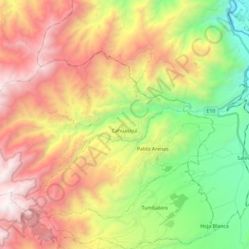
Name: Cahuasqui topographic map, elevation, terrain.
Location: Cahuasqui, San Miguel de Urcuquí, Imbabura, Ecuador (0.46851 -78.33333 0.56611 -78.16708)
Average elevation: 3,038 m
Minimum elevation: 1,767 m
Maximum elevation: 4,485 m
Thank you for supporting this site ❤️
Make a donation
Make a donation
Other topographic maps
Click on a map to view its topography, its elevation and its terrain.
Iruguincho
Ecuador > Imbabura > San Miguel de Urcuquí > San Blas > Iruguincho
Average elevation: 2,516 m