
D’Entrecasteaux Islands topographic map
Interactive map
Click on the map to display elevation.
About this map
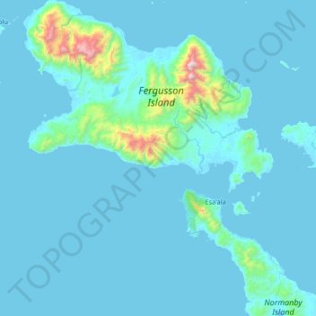
Name: D’Entrecasteaux Islands topographic map, elevation, terrain.
Average elevation: 102 m
Minimum elevation: -1 m
Maximum elevation: 1,903 m
Other topographic maps
Click on a map to view its topography, its elevation and its terrain.
Fergusson-Insel
Fergusson-Insel, Esa’ala District, Milne Bay, Papua Region, Papua-Neuguinea
Average elevation: 98 m
Goodenough-Insel
Goodenough-Insel, Esa’ala District, Milne Bay, Papua Region, Papua-Neuguinea
Average elevation: 103 m