
Fond Lorraine topographic map
Interactive map
Click on the map to display elevation.
About this map
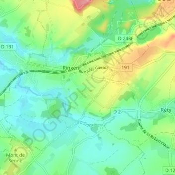
Name: Fond Lorraine topographic map, elevation, terrain.
Average elevation: 43 m
Minimum elevation: 8 m
Maximum elevation: 122 m
Other topographic maps
Click on a map to view its topography, its elevation and its terrain.
Ferme des Combles
France > Hauts-de-France > Pas-de-Calais > Rinxent
Ferme des Combles, Rinxent, Boulogne-sur-Mer, Pas-de-Calais, Hauts-de-France, France métropolitaine, 62720, France
Average elevation: 49 m