
Thank you for supporting this site ❤️
Make a donation
Make a donation
New Lexington topographic map
Click on the map to display elevation.
Thank you for supporting this site ❤️
Make a donation
Make a donation
About this map
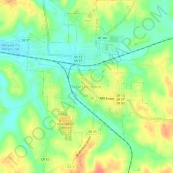
Name: New Lexington topographic map, elevation, terrain.
Location: New Lexington, Perry County, Ohio, United States (39.69611 -82.22455 39.73168 -82.18130)
Average elevation: 279 m
Minimum elevation: 255 m
Maximum elevation: 311 m
Thank you for supporting this site ❤️
Make a donation
Make a donation
Other topographic maps
Click on a map to view its topography, its elevation and its terrain.