
Thank you for supporting this site ❤️
Make a donation
Make a donation
Chandel topographic map
Click on the map to display elevation.
Thank you for supporting this site ❤️
Make a donation
Make a donation
About this map
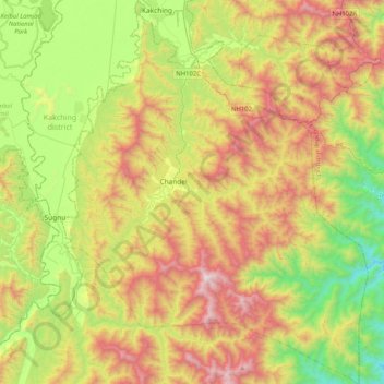
Name: Chandel topographic map, elevation, terrain.
Location: Chandel, Manipur, 795127, India (24.13407 93.88062 24.50667 94.20862)
Average elevation: 966 m
Minimum elevation: 303 m
Maximum elevation: 1,897 m
Thank you for supporting this site ❤️
Make a donation
Make a donation
Other topographic maps
Click on a map to view its topography, its elevation and its terrain.
Thank you for supporting this site ❤️
Make a donation
Make a donation
Thank you for supporting this site ❤️
Make a donation
Make a donation
Thank you for supporting this site ❤️
Make a donation
Make a donation