
Daïra Laghouat topographic map
Interactive map
Click on the map to display elevation.
About this map
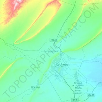
Name: Daïra Laghouat topographic map, elevation, terrain.
Location: Daïra Laghouat, Laghouat, Algérie (33.70405 2.71798 33.98088 3.04302)
Average elevation: 845 m
Minimum elevation: 736 m
Maximum elevation: 1,400 m
Other topographic maps
Click on a map to view its topography, its elevation and its terrain.
Laghouat
Algérie > Laghouat > Daïra Laghouat
Laghouat, Daïra Laghouat, Laghouat, Algérie
Average elevation: 832 m