
Thank you for supporting this site ❤️
Make a donation
Make a donation
Anakkampoyil topographic map
Click on the map to display elevation.
Thank you for supporting this site ❤️
Make a donation
Make a donation
About this map
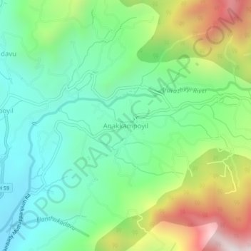
Name: Anakkampoyil topographic map, elevation, terrain.
Location: Anakkampoyil, Thamarassery, Kozhikode, Kerala, India (11.41770 76.04131 11.45770 76.08131)
Average elevation: 396 m
Minimum elevation: 40 m
Maximum elevation: 1,128 m
Thank you for supporting this site ❤️
Make a donation
Make a donation
Other topographic maps
Click on a map to view its topography, its elevation and its terrain.