
Baltimore topographic map
Interactive map
Click on the map to display elevation.
About this map
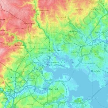
Name: Baltimore topographic map, elevation, terrain.
Location: Baltimore, Maryland, USA (39.19723 -76.71130 39.37197 -76.52968)
Average elevation: 51 m
Minimum elevation: -5 m
Maximum elevation: 158 m
Other topographic maps
Click on a map to view its topography, its elevation and its terrain.
Grahams Green Acres
USA > Maryland > Grahams Green Acres
Grahams Green Acres, Carroll County, Maryland, 21776, USA
Average elevation: 223 m
Inspiration Lake
USA > Maryland > Gaithersburg
Inspiration Lake, Inspiration Lane, Bridlewood, Gaithersburg, Montgomery County, Maryland, 20878, USA
Average elevation: 119 m