
Thank you for supporting this site ❤️
Make a donation
Make a donation
Sheboygan Falls topographic map
Click on the map to display elevation.
Thank you for supporting this site ❤️
Make a donation
Make a donation
About this map
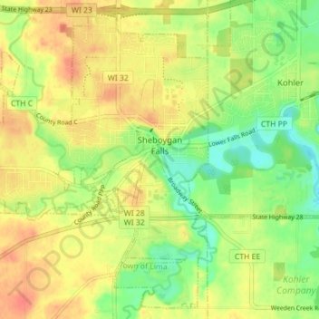
Name: Sheboygan Falls topographic map, elevation, terrain.
Average elevation: 212 m
Minimum elevation: 188 m
Maximum elevation: 232 m
Thank you for supporting this site ❤️
Make a donation
Make a donation
Other topographic maps
Click on a map to view its topography, its elevation and its terrain.
Sheboygan Marsh 2 WP 319 Dam
United States > Wisconsin > Sheboygan County > Town of Russell
Average elevation: 284 m