
Ferdinand topographic map
Interactive map
Click on the map to display elevation.
About this map
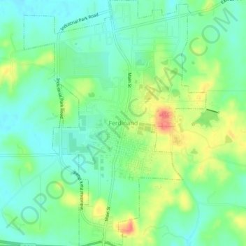
Name: Ferdinand topographic map, elevation, terrain.
Location: Ferdinand, Dubois County, Indiana, 47532, United States (38.20644 -86.88021 38.24140 -86.84721)
Average elevation: 162 m
Minimum elevation: 142 m
Maximum elevation: 199 m
Other topographic maps
Click on a map to view its topography, its elevation and its terrain.
Hillham
United States > Indiana > Dubois County
Hillham, Dubois County, Indiana, United States
Average elevation: 208 m
Celestine
United States > Indiana > Dubois County
Celestine, Dubois County, Indiana, 47580, United States
Average elevation: 185 m
Jasper
United States > Indiana > Dubois County > Jasper
Jasper, Dubois County, Indiana, 47546, United States
Average elevation: 150 m
Holland
United States > Indiana > Dubois County > Holland
Holland, Dubois County, Indiana, United States
Average elevation: 155 m
Jasper
United States > Indiana > Dubois County > Jasper
Jasper, Dubois County, Indiana, United States
Average elevation: 151 m
Huntingburg
United States > Indiana > Dubois County
Huntingburg, Dubois County, Indiana, 47542, United States
Average elevation: 148 m