
Îles de Boucherville topographic map
Interactive map
Click on the map to display elevation.
About this map
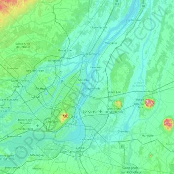
Name: Îles de Boucherville topographic map, elevation, terrain.
Average elevation: 38 m
Minimum elevation: -8 m
Maximum elevation: 387 m
Other topographic maps
Click on a map to view its topography, its elevation and its terrain.
Parc national des Îles-de-Boucherville
Canada > Québec > Longueuil (agglomeration) > Boucherville
Parc national des Îles-de-Boucherville, Sentier L'Île-de-la-Commune, Boucherville, Longueuil (agglomeration), Montérégie, Québec, J4B 1W9, Canada
Average elevation: 11 m