
Marlesreuth topographic map
Interactive map
Click on the map to display elevation.
About this map
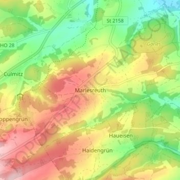
Name: Marlesreuth topographic map, elevation, terrain.
Location: Marlesreuth, Naila, Landkreis Hof, Bayern, 95119, Deutschland (50.27876 11.67380 50.31876 11.71380)
Average elevation: 595 m
Minimum elevation: 501 m
Maximum elevation: 696 m
Other topographic maps
Click on a map to view its topography, its elevation and its terrain.
Döbrastöcken
Deutschland > Bayern > Landkreis Hof > Naila
Döbrastöcken, Naila, Landkreis Hof, Bayern, 95131, Deutschland
Average elevation: 646 m
Schneckengrün
Deutschland > Bayern > Landkreis Hof > Naila
Schneckengrün, Naila, Landkreis Hof, Bayern, 95119, Deutschland
Average elevation: 574 m
Lippertsgrün
Deutschland > Bayern > Landkreis Hof > Naila > Lippertsgrün
Lippertsgrün, Naila, Landkreis Hof, Bayern, 95119, Deutschland
Average elevation: 633 m
Linden
Deutschland > Bayern > Landkreis Hof > Naila > Linden
Linden, Naila, Landkreis Hof, Bayern, 95119, Deutschland
Average elevation: 557 m