
Altenmünster topographic map
Interactive map
Click on the map to display elevation.
About this map
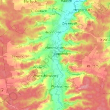
Name: Altenmünster topographic map, elevation, terrain.
Location: Altenmünster, Landkreis Augsburg, Bayern, 86450, Deutschland (48.41889 10.52792 48.49921 10.64556)
Average elevation: 487 m
Minimum elevation: 425 m
Maximum elevation: 535 m
Other topographic maps
Click on a map to view its topography, its elevation and its terrain.
Biberbach
Deutschland > Bayern > Landkreis Augsburg
Biberbach, Landkreis Augsburg, Bayern, 86485, Deutschland
Average elevation: 462 m
Dinkelscherben
Deutschland > Bayern > Landkreis Augsburg > Dinkelscherben
Dinkelscherben, Landkreis Augsburg, Bayern, 86424, Deutschland
Average elevation: 501 m