
广水市 topographic map
Interactive map
Click on the map to display elevation.
About this map
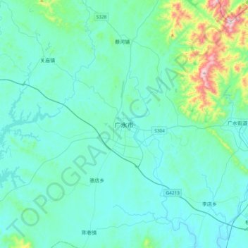
Name: 广水市 topographic map, elevation, terrain.
Location: 广水市, 随州市, 湖北省, 432700, 中国 (31.45901 113.66035 31.77901 113.98035)
Average elevation: 138 m
Minimum elevation: 45 m
Maximum elevation: 797 m
广水地处桐柏山脉南麓、大别山脉西端, 属低山丘陵地带。最高处大贵山海拨907.8米,最低处平林的河床海拔仅37米。
Other topographic maps
Click on a map to view its topography, its elevation and its terrain.