
Deux Acren topographic map
Interactive map
Click on the map to display elevation.
About this map
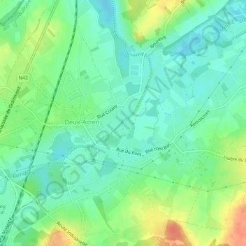
Name: Deux Acren topographic map, elevation, terrain.
Average elevation: 26 m
Minimum elevation: 10 m
Maximum elevation: 54 m
Other topographic maps
Click on a map to view its topography, its elevation and its terrain.
Twee-Akren
België > Henegouwen > Aat > Lessen > Twee-Akren
Twee-Akren, Lessen, Aat, Henegouwen, Wallonië, 7864, België
Average elevation: 29 m