
Thank you for supporting this site ❤️
Make a donation
Make a donation
Kraiburg am Inn topographic map
Click on the map to display elevation.
Thank you for supporting this site ❤️
Make a donation
Make a donation
About this map
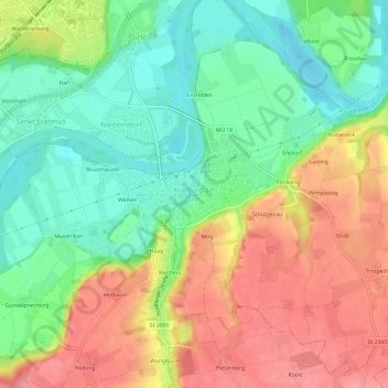
Name: Kraiburg am Inn topographic map, elevation, terrain.
Average elevation: 430 m
Minimum elevation: 383 m
Maximum elevation: 484 m
Thank you for supporting this site ❤️
Make a donation
Make a donation
Other topographic maps
Click on a map to view its topography, its elevation and its terrain.
Schloss Guttenburg
Deutschland > Bayern > Landkreis Mühldorf am Inn > Kraiburg > Frauendorf
Average elevation: 427 m