
Johnson creek topographic map
Interactive map
Click on the map to display elevation.
About this map
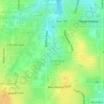
Name: Johnson creek topographic map, elevation, terrain.
Average elevation: 198 m
Minimum elevation: 184 m
Maximum elevation: 213 m
Other topographic maps
Click on a map to view its topography, its elevation and its terrain.
Lake Arlington
United States > Texas > Tarrant County > Arlington
Lake Arlington, Arlington, Tarrant County, Texas, United States
Average elevation: 179 m
La Frontera
United States > Texas > Tarrant County > Arlington > La Frontera
La Frontera, Arlington, Tarrant County, Texas, 76002, United States
Average elevation: 185 m